Mobile mapping market to register a double-digit growth over 2018-2024, agricultural sector to emerge as a lucrative end-use segment
Publisher : Fractovia | Published Date : 2018-10-10Request Sample
Having endorsed its name in one of the hottest business sphere of sustainable & smart technologies, mobile mapping market, over the past few years has been drawing colossal investments. Widely used across the organizations for fleet management, maintenance of cable network, asset management, and construction, mobile mapping technology has been gaining immense traction in navigational applications, GPS/GNSS systems, GIS data collection, asset management, and in road & railway survey. Estimates claim that mobile mapping market in 2017 amassed a remuneration portfolio of USD 14 billion.
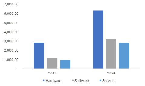
U.S. Mobile Mapping Market Revenue, By Component

Furthermore, the advent of new technologies such as the Internet of Things, AI, and LiDar has fostered the industry players in transforming mobile mapping technology in the recent years. Recently for instance, leveraging the advancements in LiDar technology, NavVis, a global indoor mobile mapping industry major, has launched the M6 mapping system that significantly overcomes the data quality constraints and scalability. The company revealed that its M6 mobile mapping system can now assist surveyors and AEC professionals with reality capture technology for applications including factory planning, major indoor mapping projects, construction monitoring, and in creating & updating as-built BIM models.
According to reliable reports, featuring a mobile LiDAR system (that captures imaging of 30,000 sq meter per day and scans 30 times faster) NavVis developed this product in response to its customers’ expectations for a more sophisticated and versatile mobile mapping system that could be used efficiently with an uneven terrain. Quite overtly, such increasing demands and importance of geospatial technologies for analyzing data, imaging, and visualization has significantly impelled the global mobile mapping industry share. The competitive landscape of this business sphere is further likely to attract lucrative growth avenues with industry contenders adopting investment and growth strategies such as M&As, R&D, JV, partnerships, and product innovation.
Speaking along similar lines, a digital mapping company TomTom has recently unveiled that in an effort undertaken to compete with Google Map’s high prices, it is now offering free mobile mapping data and software tools to help developers add navigation features to their applications. The company’s software development kit, reportedly has free of cost map & traffic related information for iOS and Android platforms. The aforementioned instance is an apt example of the growing competitiveness among the industry players for strengthening their position in the global mobile mapping market. Apart from the core players, Apple, Baidu, and Google are other industry magnates who are heavily leveraging the mobile mapping solutions to enhance their accuracy in maps and acquire the georeferenced data.
From the above mentioned instances, it is quite evident that technological proliferation, cost-effectiveness, and product innovation, unquestionably, play a crucial role in the expansion of the competitive and application spectrum of mobile mapping industry. In this regard, it is prudent to mention that the agriculture sector is likely to emerge as is one of the hottest investment hubs for potential mobile mapping market stakeholders. For the record, mobile market industry size from the agricultural sector is slated to register a healthy CAGR of 22% over 2018-2024. The integration of the GNSS and GPS devices into the agriculture and farming process to acquire geospatial data is promoting mobile mapping market revenue share from this segment.
Other important end-use sectors comprising the government & public sector, mining, transport & logistics, BFSI, retail, real estate, and telecommunication, are also expected to exhibit heightened product demand in the ensuing years.
It is thus rather overt that the global mobile mapping market has been making an appreciable headway in smart & sustainable technologies business space, on account of the escalating application scope, end-use segment, technological developments, and geographical expanse. With 3D mobile mapping further emerging as a future technology overcoming the current limitations of mobile mapping, the commercialization potential of the overall industry is forecast to be considerably high in the ensuing years. A presumption validating the same is of Global Market Insights, Inc., that claims mobile mapping market to surpass USD 40 billion by 2024.